Master Your Flight Skills
Welcome to the „Master Your Flight Skills“ section, where we focus on enhancing your piloting abilities through various training and resources. One of the key features of this program is our detailed exploration of Koh Samui Airport (VTSM) which is one of the Focus Airports.
Koh Samui (VTSM)
Koh Samui Airport presents several unique challenges and features that make it an interesting and demanding destination for pilots. Here are some of the key aspects:

Short Runway
Koh Samui has a relatively short runway (6890 ft), which requires precise landing techniques and careful speed management, especially for larger aircraft. A performance calculation is absolutely necessary.
Terrain
The airport is surrounded by hilly terrain and mountainous regions, necessitating careful approach and departure procedures to avoid obstacles.
Weather Conditions
Koh Samui often experiences tropical weather, including heavy rain and strong winds, particularly during the monsoon season in October to December. This can make approaches and landings more challenging because of turbulence, cloud cover and a wet runway.
Visual Approach & Limited Navigation Aids
Due to the terrain and proximity to the sea, you often have to rely on visual approach procedures, requiring excellent situational awareness and visual flying skills. The airport has no ILS and only limited navigation aids, offering only VOR or RNP approaches. This means you must be proficient in manual flying and visual navigation techniques.
Your briefing starts here
Let’s start with checking the METAR: VTSM 202200Z 26008KT 9999 FEW020 28/24 Q1006 NOSIG
Explanation of METAR for VTSM:
VTSM: The ICAO airport code for Koh Samui Airport.
202200Z: The date and time of the observation. „20“ refers to the 20th day of the month, and „2200Z“ means the observation was taken at 2200 UTC (Coordinated Universal Time).
26008KT: The wind is coming from 260 degrees (west) at 8 knots.
9999: Visibility is 10 kilometers or more. | According to the chart we need min. 4800m
FEW020: Few clouds at 2000 feet above ground level.
28/24: The temperature is 28 degrees Celsius, and the dew point is 24 degrees Celsius.
If the temperature drops to the dew point (distance is 3°C or less) , fog or mist can form, reducing visibility significantly. That means we maybe have to take fog or mist into account.
Q1006: The atmospheric pressure at sea level is 1006 hPa (hectopascals).
NOSIG: No significant weather changes are expected in the near future.
OFP & landing performance calculation
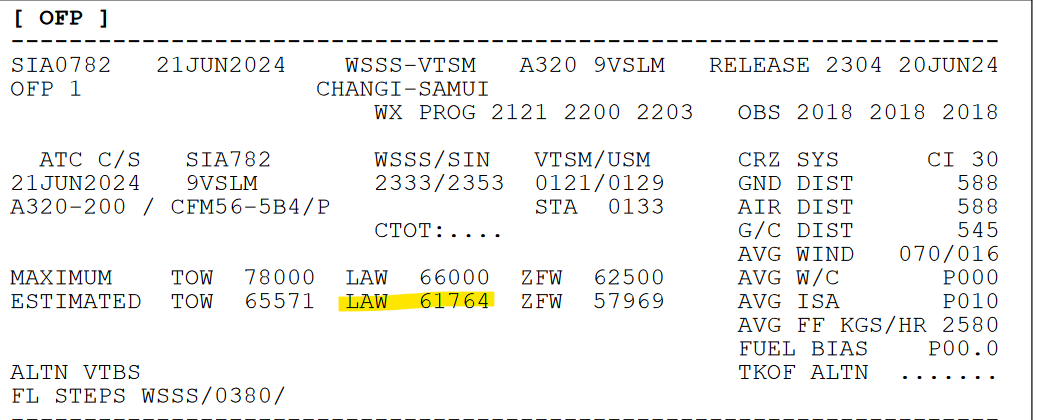
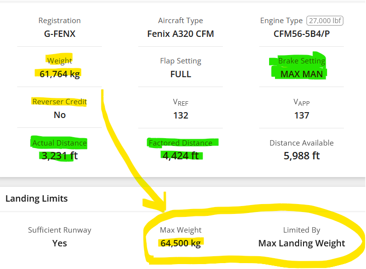
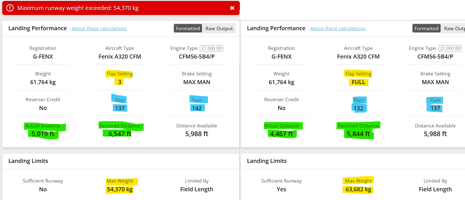
Let’s take a look at the OFP. Our estimated landing weight will be approximately 61,800 kg. This is an important factor in our landing performance calculation. I have highlighted all the weights in yellow. Accordingly, we can land with Flaps Full and Max MAN (I will explain later) with a maximum weight of 64,500 kg. So, we’re good on that front. By the way, the reversers are never included in the calculations, so always set them to „no credit.“
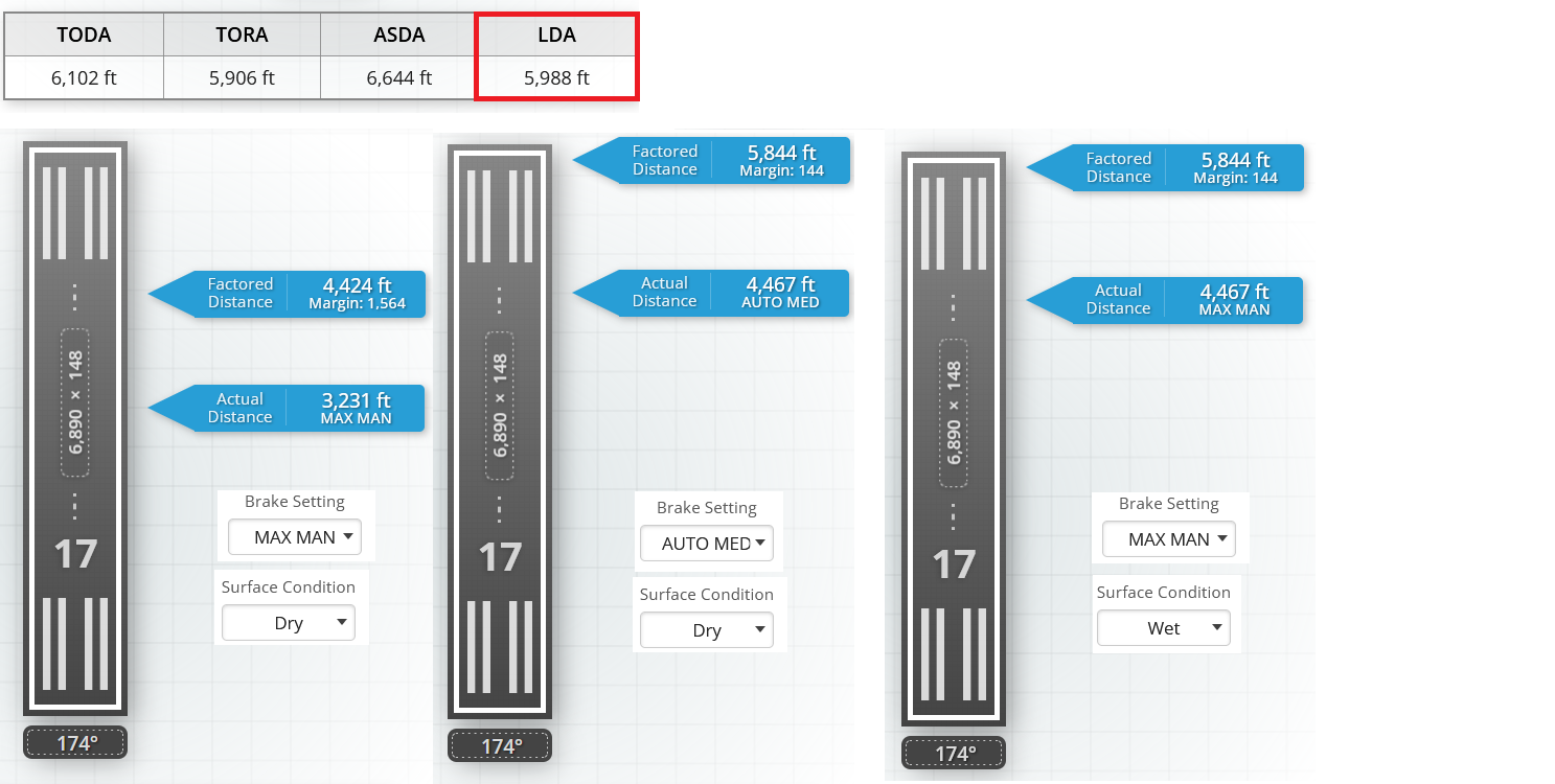
Now let’s check the green marked braking distance and brake settings. The main focus is on our LDA (Landing distance available) which is 5988 feet. So I did various calculations. Max Manual, Auto MED and a wet runway. It’s clear that we can only land using „Max Manual“ brakes. Using Auto MED or Max MAN and a wet runway would lead us to the end of the runway without sufficient safety distance. Btw we use „inflight method“ calculating a 7 second flare time from threshold to touchdown, plus an additional 15% safety margin.
Lastly, we need to consider the flap setting. Approaching with Flaps 3 instead of Full results in higher VRef/VApp speeds and a significantly longer landing distance, reducing our maximum landing weight. The choice between Flaps Full and Flaps 3 depends on runway length, weather conditions, aircraft weight, and operational requirements. In my experience, when landing performance allows, I prefer Flaps 3 for efficiency or better stability in strong winds. However, on short runways and with favorable wind conditions, I use Flaps Full. To solve this puzzle: only Flaps Full is feasible here.
Let’s check the charts
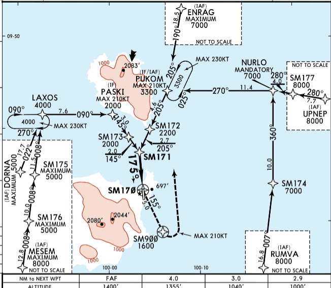
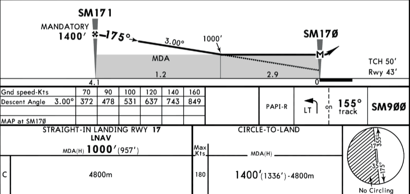
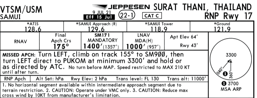
We will approach Koh Samui from the south via RUMVA, which is our IAF (Initial Approach Fix), towards NURLO, PUKOM, SM171 and RWY17. We have an RNP approach starting from 1400 feet at SM171, which is 4.1 NM away.
We have a standard descent angle of 3°, with PAPIs on the right-hand side. Our minimums are 1000 feet, and the minimum visibility is 4800 meters. This matches the METAR data.
In case of a missed approach, we turn left and climb on track 155° to SM900, then turn left direct to PUKOM at a minimum of 3300 feet or hold as directed by ATC with a maximum speed of 210 kts.
Once we’re cleared to an altitude or when we pass the transition layer, set the barometer to the local QNH. Remember to adjust the standby instrument as well.
And here is how it’s done with an A320-200
Okay, we begin our descent from 10,000 feet (FL100). Turn on the landing lights and seatbelt signs. On the FCU, select CSTR, (LS is not used for an RNP approach), and set the range to 20 NM. Check the Progress Page to ensure the accuracy is high, as we require a maximum deviation of 0.3 NM. Set the ENG Mode Selector to IGN in case of standing water on the runway, heavy rain, or severe turbulence; otherwise, set it to NORM. Once we’re cleared to an altitude or when we pass the transition layer, set the barometer to the local QNH. Remember to adjust the standby instrument as well.
Approximately 2 NM before PUKOM, reduce the speed below Green Dot Speed to S Speed and set Flaps 1. At 2500 feet, set Flaps 2 to activate the ECAM. Immediately after, extend the gear and set Flaps 3. Follow this sequence to avoid overloading the hydraulic pumps. Arm the spoilers and switch on the nose light and RWY turnoff lights. Set Flaps Full and complete the landing checklist. At 500 feet, check if we are stable, meaning the localizer and glideslope bars (no magenta ILS diamonds) are centered. Disengage the autopilot no later than 300 feet AGL (above ground level).
Happy landings!
Note: This is not an ILS approach, so do not use the approach button on the FCU. We are flying an RNP approach, which means we will see bars instead of magenta diamonds.